Forward Projections
After the recent record rain and the previous summer’s record dry, what does this winter’s climate have in store?
Key points:
- Autumn is the most difficult season to make long-term climate forecasts
- The main climate drivers are often in neutral in autumn
- Seasonal forecasts become more accurate as climate drivers become clearer in winter
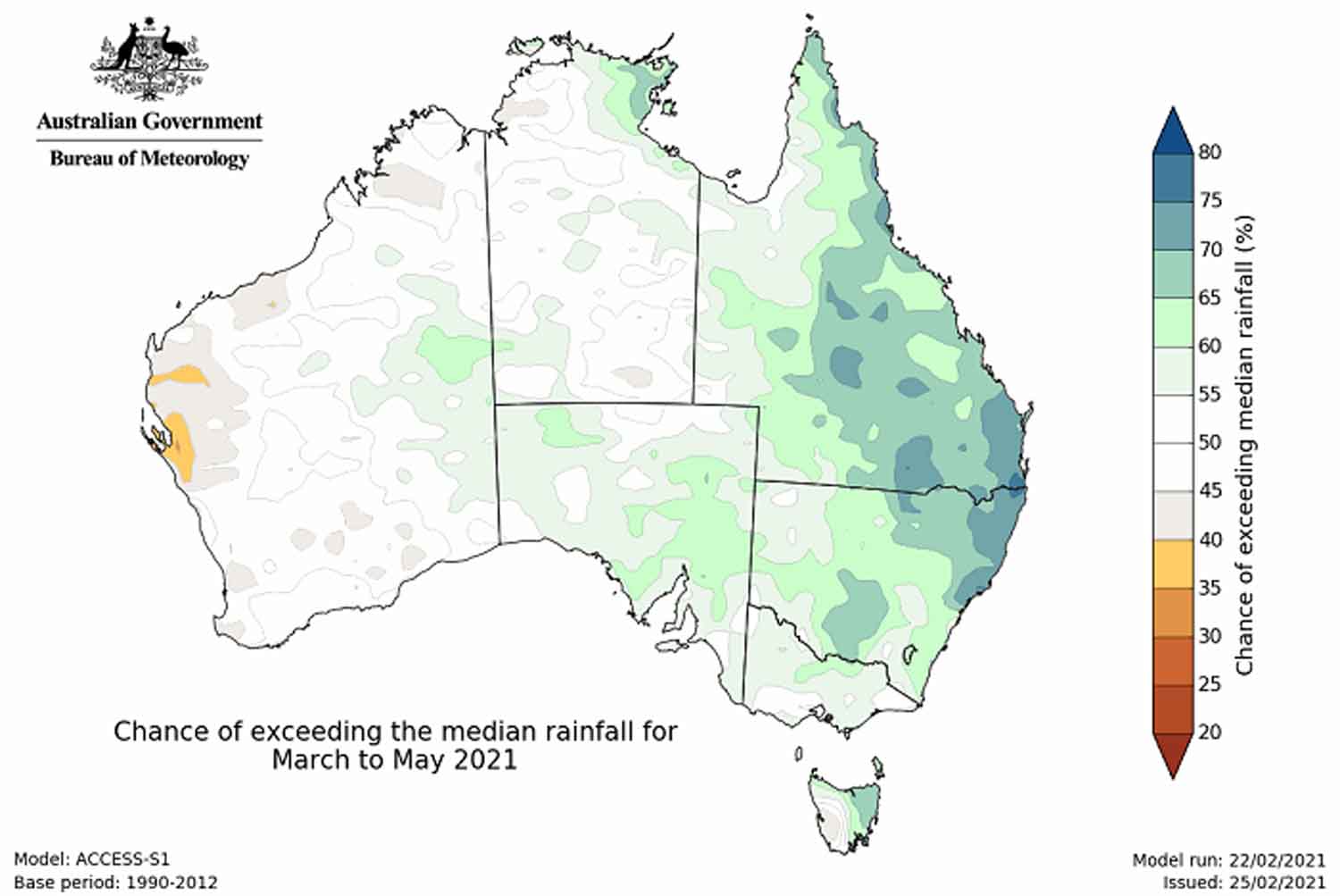
The Bureau of Meteorology is predicting April to June to be likely wetter than average across the north of Australia and drier than average for the southern half of Queensland, inland parts of NSW and Victoria, and far eastern SA.
But making seasonal forecasts at this time of year is difficult, due to what forecasters call the “autumn predictability barrier”.
“At this time of year, we’re probably at the lowest point at the moment in terms of skill in predicting seasonal drivers such as El Niño, La Niña, or the Indian Ocean Dipole,” said Felicity Gamble, a climatologist from the Bureau of Meteorology.
Climate reset switch
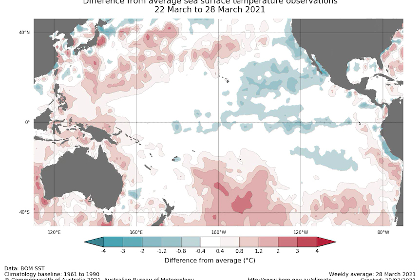
Dr Gamble said that in March and April, the world’s climate often underwent a global “reset”, where El Niño/La Niña (ENSO) and the Indian Ocean Dipole returned to neutral, making it harder to predict what the upcoming season would bring.
“This is what we’ve just seen with this most recent La Niña, which just returned to neutral values,” Dr Gamble said.
“It’s also the time when we start to see early signs of the next climate-driver event developing. Often it starts to show a few little signs at this time of year before becoming more established during the winter months,” she said.
In other words, at this time of year, the crucial ocean temperatures that drive the Australian climate could go either way, and small weather events in the tropics can lead to big climate impacts later in the year.
“It’s like a reset switch. And we’re starting again with the next cycle,” Dr Gamble said.
Climate in neutral gear
Right now, Australia’s two big climate drivers, ENSO and the IOD, are in neutral.
At times like this, Australian weather becomes more influenced by shorter-term drivers like the Madden-Julian Oscillation, or MJO, which mainly affects northern Australia.
“The MJO is going to be the strongest driver of our rainfall patterns over the next few weeks as it comes into the Australian region,” Dr Gamble said.
In fact, weather models are predicting the development of a low off the north-west of Australia over the coming days, as the MJO influences northern Australia.
Beyond this, the Bureau of Meteorology said May showed a mostly neutral climate signal, with some areas of the east likely to be drier than average.
Climate secrets deep in the ocean
Researchers in Australia are working to break through the autumn predictability barrier, in part by better understanding ocean temperatures below the sea surface.
El Niño and La Niña events can be first detected in changes in sub-surface water temperatures, according to Harun Rashid, a principal research scientist with the CSIRO Climate Science Centre.
“If we include the sub-surface temperature in climate models, for example the ocean temperatures at 300 metres’ depth, as well as the surface temperature, then you have less of a predictability barrier,” he said.
At the Bureau of Meteorology, senior research scientist Andrew Marshall said it was hard to make long-term predictions at this time of year because the oceans had not yet coupled with the atmosphere.
“By coupled, I mean the atmosphere and the ocean working together,” he said.
“For example, when the ocean starts to warm, then the atmosphere above that ocean will respond. And then that can reinforce the warming in the ocean.
“It’s really once the atmosphere and ocean couple, that we then we can better understand how these events will evolve. And we then have better prediction skill, and typically that occurs from about May onwards.”
BOM forecasts wet autumn for some as La Niña weather system declines
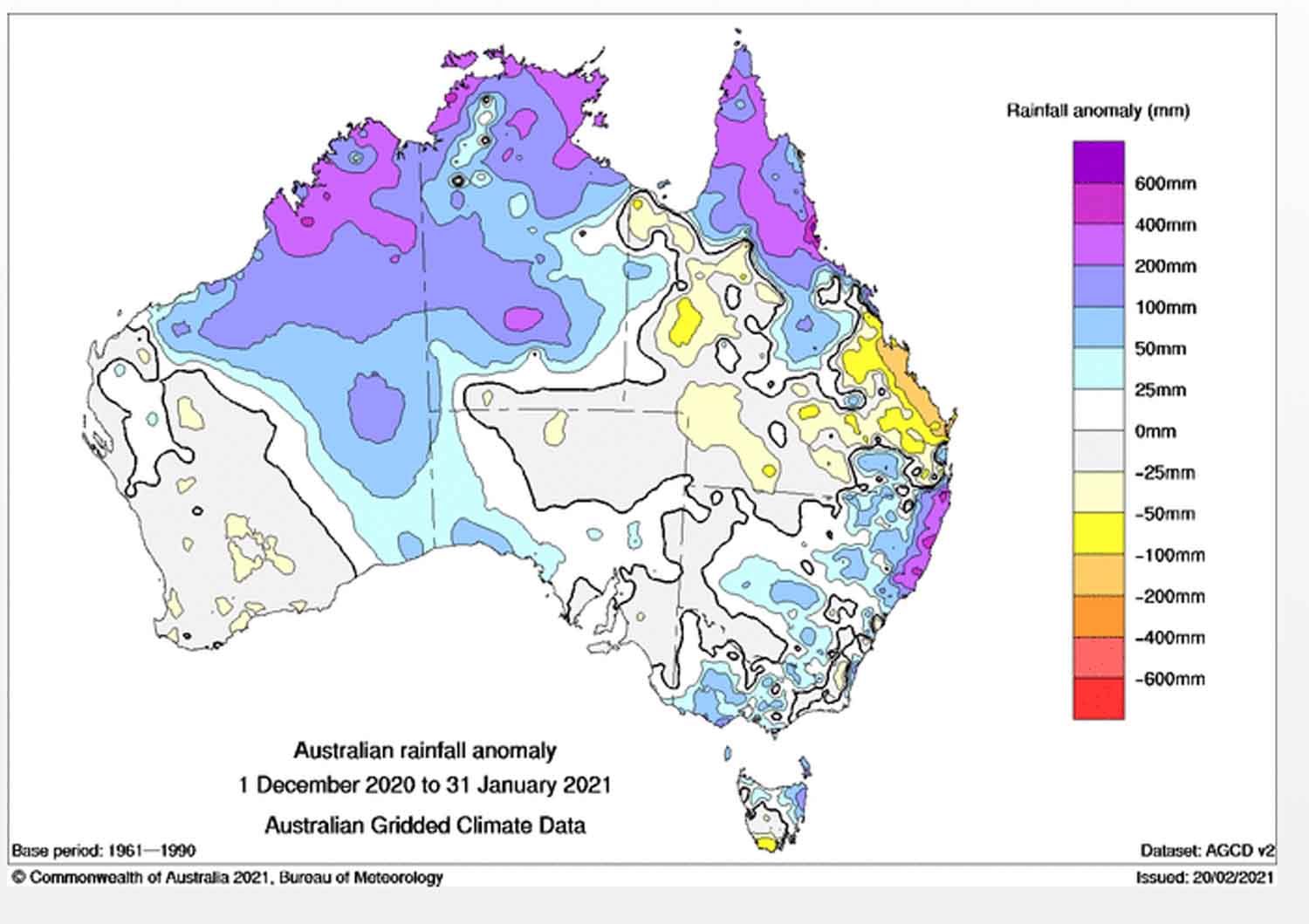
The much-discussed La Niña phenomenon has brought the best wet season for years in the Top End and a welcome change to rainier conditions for most of the country, but some still missed out this summer.
And the Bureau of Meteorology [BOM] autumn outlook is for wetter-than-average conditions in the east.
Key points:
BOM suggests wetter than average conditions are expected to continue for eastern Australia
La Niña is set to bid farewell but there are encouraging signs of rain for those who need it
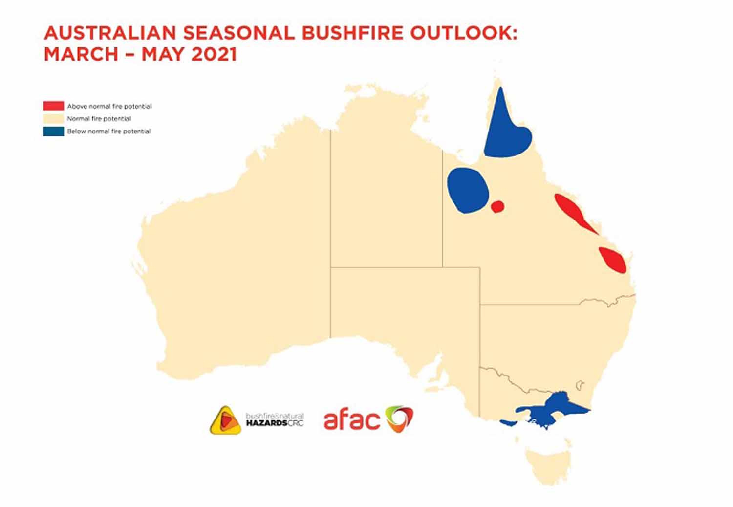
Bushfires risks will remain for parts of WA and Queensland this autumn
According to BOM climatologist Naomi Benger, La Niña will continue to wield influence into autumn even though it is weakening.
“The typical lifecycle of La Niña is that it decays through autumn,” she said.
“We are expecting it to decay through early autumn, but we are still seeing quite strong signals in the atmosphere, even though some of the oceanic measurements are hinting towards the decay.”
Hence, encouraging signs of rain in areas that need it.
“We are expecting above average rainfall in eastern and some northern parts, including those parts of Queensland that have missed out so far this year,” Dr Benger said.
And cyclone season isn’t over until the end of April.
Above-average minimum temperatures are expected to continue across most of the country, with the exception of central and western South Australia and south-eastern Western Australia.
Daytime temperatures are expected to be above average for the far north and south as well as the far west.
Bring on the wet
So far, La Niña’s impact has fallen well short of infamous flood years like 2011 and 1974.
Summer still has a few days to go and, according to Dr Benger, rain has been above average for the nation as a whole and the highest seen since the summer of 2016-17.
Bushfire outlook
That was a sentiment echoed by John Bates, research director at the Bushfire and Natural Hazards Cooperative Research Centre.
The official autumn bushfire outlook, also released today, suggests most of the country can expect average fire conditions this autumn.
But according to Dr Bates the risk of grass and crop fires continues in the coming months, particularly where rain has created good growing conditions.
“Autumn will still see hot and windy days that raise the fire risk in some locations,” he said.
Areas that have missed out on rain so far in Queensland are at above average risk.
“But when the weather conditions allow, the March to May period is a good time of year for prescribed burning,” according to Dr Bates.
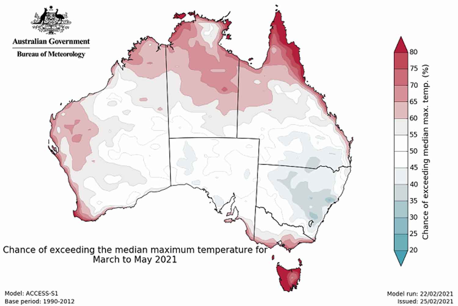 Maximum temperatures are expected to be average for much of continental Australia but above average around the coasts and for Tasmania.(Bureau of Meteorology)
“However, in northern Australia, the good wet season means that prescribed burning will be difficult in the coming months.”
Notes
Further information on the current status of ENSO can be found in the ENSO Wrap-Up.
Details: ENSO Wrap-Up
Always monitor our Facebook page and listen on air on the FM band 101.5 Mhz or listen live via our website above.