Short term weather trends 2020 Season
NOTE: this page is now on its own dedicated page located at https://1015fm.com.au/weathertrends/
Please note: Weather information is guided by the Bureau Of Meteorology , Oz Cyclone Chasers , Moreton Bay Regional Council and observations at Caboolture & surrounding districts of the Moreton Bay Region at 101.5 FM.
Declarations :
None
Resources:
Power Outages, Translink Train,
Recent related stories:
Powerline down safety campaign designed to save lives
Are you prepared for an emergency, any emergency at a moments notice?
Do Not Let Complacency surprise you when an Emergency strikes
Current Weather Events:
Very Short Term Weather/Month ahead
August 25 to September 01
Surface Trough crossing Queensland from Central Australia with Coral Seas moisture flows with Wet conditions for Inland and Coastal South East Queensland.
September 01 to September 08
Mostly Dry Conditions South East Queensland.
September 08 to September 15
Mostly Dry Conditions for South East Queensland.
September 15 to September 22
Wet period this week for South East Queensland.
September 22 to September 29
Surface Trough extending from Darwin to South East Vioctoria will bring a significant Wet period this week with Thunderstorms for South East Queensland.
September 29 to October 6
General Wet Signal for South East Queensland
The Coral Sea is un-seasonally warmer then normal for this time of year
Towards end of August to Early September
On shore moisture from the Coral sea may impact on additional shower activity as we enter a more La Niña conditions
Long Range Note: the last time we had the below scenario since 2011/2012, increased warming of waters in the coral sea is also noted, the cold blast is unlikely to appear in May rather held off until June, meaning temperatures will remain relatively warm, Coral Sea water temperatures will remain above average. Trends for a La Niña or cool neutral year next season and a negative IOD with Indian Ocean cooling, this winter will be polar opposites to last year.
August above average rainfall with enhanced easterly air flows and tropical mix
September above average rainfall with enhanced easterly air flows and tropical mix, heavy storm activity
October above average rainfall with enhanced easterly air flows, Trough Systems and tropical mix, heavy storm activity
November above average rainfall with enhanced easterly air flows and tropical mix, forward projects have November being a possible record breaking rain month and on time or early monsoon for December, however South East Queensland more dryer
December Early start of monsoon and Heavy rainfall for Queensland in General including South East Queensland.
January 2021 Generally heavy rainfall for Queensland except for South East Queensland with dry conditions overall.
IOD is heading to more weak negative and with cooling eastern pacific waters show El Niño now moving fast to a La Niña as we head toward next year.
The Bureau of Meteorology’s spring outlook suggests we could be in for a wetter-than-average spring for eastern Australia, but after a dry start.
Key points:
- Spring is likely to get off to a dry start but is expected to be wetter than average by the end of the season
- Dam levels have bounced back in parts of New South Wales, the ACT and Victoria
- But some regions are still well behind when it comes to rainfall and water storage
Naomi Benger, climatologist with the BOM, said the rainfall outlook was broadly neutral or for slightly below-average rainfall for the end of winter and start of spring.
Over the next few weeks, drier conditions are expected through central Queensland, the Northern Territory and northern Western Australia — regions that would typically be dry this time of year anyway — but also for the agricultural areas of South Australia, western Victoria and southern WA.
This might be surprising news, given the BOM announced a La Nina alert, with a 70 per cent chance of the traditionally wet climate driver occurring by the end of the year, just last week.
Dr Berger said we were seeing the atmosphere respond to the cooler waters through a strengthening of the trade winds, as would be expected with a La Nina.
Queensland Fire and Emergency Services advises that people should:
* Never drive, walk or ride through flood waters. If it’s flooded, forget it.
* Seek shelter, preferably indoors and never under trees.
* Avoid using the telephone during a thunderstorm.
* Beware of fallen trees and powerlines.
* For emergency assistance contact the SES on 132 500
Current Weather Warnings
Forward Projections
Forward Projections:
BOM declares La Nina alert, with 70pc chance of forming in 2020
The odds of a La Nina in the coming months have improved to a 70 per cent chance — roughly three times the normal likelihood — and it’s not the only climate driver that could potentially favour wet conditions heading into spring.
Key points:
BOM says the chances of a La Nina forming in the coming months is three times more likely than normal
La Ninas are associated with wet conditions for Australia but sometimes don’t result in widespread rain
How it plays out will depend on the other climate drivers and individual weather systems
Bureau of Meteorology (BOM) climatologist Naomi Benger said La Nina could mean a few different things for the Australian region.
“One of them is enhanced rainfall for central, eastern and northern Australia,” she said.
“So while some areas might welcome that bit of extra rain if they’ve been in drought, it can lead to an elevated risk of flooding.”
La Nina events are also associated with heightened risk of cyclones as well as cool daytime temperatures.
“There is generally more cloud and more soil moisture, which means the daytime temperatures could be a little bit lower on average,” Dr Benger said.
La Ninas are typically wet, but …
Weather nerds with good memories will recall a La Nina was declared in 2017 and, rather than bringing widespread rains, it was the beginning of the latest drought.
Dr Benger said that La Nina did not last long enough for the impacts to really manifest.
“The last significant La Nina event was in 2010-11, and that was Australia’s wettest two-year period on record,” she said.

Many will remember that summer for widespread flooding along the east coast, including the worst floods in Brisbane since 1974.
So are we looking at a 2017-18 or a 2010-11 kind of event?
Dr Benger said it was difficult to say at this stage, and the BOM’s announcement did not guarantee Australia will reach La Nina thresholds this year.
“At the moment there’s a 70 per cent chance of it developing, but really how it manifests will depend on the other climate drivers as well.”
The other climate drivers
Over the past few years, the positive phase of the Indian Ocean Dipole (IOD) has been dominant, bringing dry conditions to eastern Australia.
This year, however, it looks like that could change.
“The IOD has been quite tricky this autumn-winter period to predict, but at the moment, three of the six models that the BOM surveys are indicating that a negative IOD could develop during spring,” Dr Benger said.
A negative IOD favours wetter-than-average conditions for Australia — but some of the models are indicating a more neutral IOD in the coming months.
“We are certainly not as confident in that as we are with the La Nina,” Dr Benger said.
But at least it currently looks unlikely we will be facing another strong positive IOD.
Then, of course, there are other drivers, like the Southern Annular Mode (SAM).
Dr Benger said while the SAM operated on a shorter time period, it would affect how far north or south frontal systems to the south of Australia moved and how far south rain-bearing systems came along the east coast.
“So that will also play into when and where we get rainfall.”
Speaking of cold fronts, a series of fronts and troughs is expected to bring strong winds, rain, hail, snow and below-average temperatures for the south-east of the country over the coming days.
Notes
The ENSO Outlook is currently INACTIVE. This means there is little sign of El Niño or La Niña developing in the coming months. The criteria will continue to be assessed each fortnight. The status will be upgraded when the criteria and expert assessment indicate an increase in the chance of an ENSO (El Niño or La Niña) event developing.
Further information on the current status of ENSO can be found in the ENSO Wrap-Up.
Details: ENSO Wrap-Up
Always monitor our Facebook page and listen on air on the FM band 101.5 Mhz or listen live via our website above.
Road Closures
Brendale Leitchs Road Pedestrian Bridge at South Pine River
Dams Update
What Should You Do?
Monitor your local conditions
Check BoM radar imagery at http://www.bom.gov.au/products/IDR663.loop.shtml
Bureau of Meteorology weather warnings
Never drive, walk or ride through flood water
Stay clear and report overflowing manholes to Unitywater
Tune in to your emergency broadcasters: ABC radio 612AM, 101.5FM and 99.7FM
Important Contacts and Links
Life threatening emergencies: Triple Zero (000)
SES flood or storm assistance: 132 500
Council: (07) 3205 0555
Council local road conditions at council’s website
Unitywater: 1300 086 489
Energex: 13 62 62
Department of Main Roads
Moreton Bay Regional Council is encouraging local residents to make sure they are prepared. Keep up to date using the MBRC Disaster Portal at www.moretonbay.qld.gov.au/disaster-portal
Seqwater advises that its Flood Operations Centre is on ALER.
What Should You Do?
Contact Triple Zero (000) for emergency assistance.
Relocate to higher ground if necessary (Higher ground maps show these areas including common road closure points).
View the latest road conditions at council’s website.
Tune in to your emergency broadcasters: ABC Radio 612AM, 101.5FM and 99.7FM.
Never drive, walk or ride through flood water. Most flood related deaths occur this way.
Seqwater will continue to monitor the situation and provide further updates.
For more information please visit:
Dam release information seqwater.com.au
Somerset Council somerset.qld.gov.au
MBRC Council moretonbay.qld.gov.au
Weather warnings, river heights bom.gov.au
Road closures and transport qldtraffic.qld.gov.au
Handy Links & Moreton Bay Regional Council Advisories
Important Contacts and Links
Sandbags in the Moreton Bay Region
Get Moreton Bay Regional Council : Moreton Alert
Life threatening emergencies: Triple Zero (000)
SES flood or storm assistance: 132 500
Council: (07) 3205 0555
Council local road conditions at council’s website
Unitywater: 1300 086 489
Energex: 13 62 62
Parking vehicles under solid shelter, with the handbrake on and in gear
Putting wooden or plastic outdoor furniture in backyard pools or inside with other loose items
Drawing curtains and shutting doors
Packing a kit with essential medications, baby formula, nappies, valuables, important papers, photos, mementoes in waterproof bags, as part of emergency kits
Checking neighbours — especially new arrivals — are aware of the situation and are preparing
Remaining indoors with pets, not moving to public shelters unless advised by local authorities
Keeping a battery operated radio and Staying tuned to local radio 101.5 for further information
Plus Moreton Bay region Checklist:
- Know the risks – think about the risks in your local area. How could a cyclone, severe storm, flood or bushfire impact you?
- Prepare your family – prepare an emergency plan about how to respond to local risks, including an emergency kit of essential items including a torch, battery operated radio and spare food and water (for at least three days).
- Prepare your property – check your gutters, roof, and insurance for house and other property. Get to know your neighbours and see if you can work together to get ready.
- Stay alert – tune in to warnings with MoretonAlert (register at Moreton Alert or call council 3205 0555), listen to radio updates or log onto the Bureau of Metereology’s website.
- Take action – activate your emergency plan, locate your emergency kit, secure loose items and if you are evacuating do so early and check road conditions before setting off.
For more information: https://getready.qld.gov.au/be-prepared and Moreton Bay Regional Council Disaster Portal
- Re-check your property for any loose material and tie down (or fill with water) all large, relatively light items such as boats and rubbish bins.
- Fill vehicles’ fuel tanks.
- Check your emergency kit and fill water containers.
- Ensure household members know which is the strongest part of the house and what to do in the event of a cyclone warning or an evacuation.
- Tune to your local radio/TV for further information and warnings.
- Check that neighbours are aware of the situation and are preparing.
https://getready.qld.gov.au/be-prepared
Moreton Bay Regional Council new webpage official Sandbags Locator
Flood Watch Advisories
Moreton Bay Regional Council:
What Should You Do?
Monitor your local conditions
Check BoM radar imagery at http://www.bom.gov.au/products/IDR663.loop.shtml
Bureau of Meteorology weather warnings
Never drive, walk or ride through flood water
Stay clear and report overflowing manholes to Unitywater
Tune in to your emergency broadcasters: ABC radio 612AM, 101.5FM and 99.7FM
Important Contacts and Links
Life threatening emergencies: Triple Zero (000)
SES flood or storm assistance: 132 500
Council: (07) 3205 0555
Council local road conditions at council’s website
Unitywater: 1300 086 489
Energex: 13 62 62
Department of Main Roads
Moreton Bay Regional Council is encouraging local residents to make sure they are prepared. Keep up to date using the MBRC Disaster Portal
Current Cyclones impacting on South East Queensland
Bureau Of Meteorology Cyclone Bulletin
If Its Flooded – Forget it !!
In the event of heavy rain falling, police are urging motorists to drive to conditions and heed the message: if it’s flooded, forget it.
Under severe storms or heavy rain bands, flash flooding can occur very quickly and without any notice – even on roads that you usually travel on without any issues.
Flash flooding can cause significant structural damage to roads, so even if you think it looks safe, you can never be sure exactly what is underneath the water.
No matter what car you drive, no matter what bike you ride, no matter what shoes you wear – if it’s flooded, forget it.
Current Fires in our listening area & Warnings
The Rural Fire Service Queensland advises you to:
- Action your Bushfire Survival Plan now.
- Monitor the fire and weather situation through your local radio station, www.ruralfire.qld.gov.au and www.bom.gov.au.
- Call 000 (Triple Zero) in an emergency.
For information on preparing for bushfires go to www.ruralfire.qld.gov.au.
.

Fire Season 2019 – Queensland bushfire season expected to last longer
Queensland emergency services are bracing for what is expected to be a long and “very active” fire season, with weather experts saying the outlook is “not a good news story”.
Significant fire activity expected from Rockhampton to the NSW border
Dry fire fighting techniques will be used in areas such as the Granite Belt and Darling Downs
About 33,000 volunteer firefighters are on call across the state
The Bushfire and Natural Hazards CRC released its bushfire outlook joined by fire representatives from across the country — who warned communities to be prepared.
Queensland Fire and Emergency Services (QFES) Deputy Commissioner Mark Roche said Queensland had already started its fire season, with several fires coming close to homes and killing wildlife in the south-east last week.
The bushfire season has started early and we expect it will go later as well.
Over the last couple of weeks we’ve seen some significant fires, we note this report in the bushfire outlook and we believe we are very well prepared.
But we need the local community, we need the local government to be prepared and support us side by side.
Bushfire Outlook 2019 (Supplied: Bushfire and Natural Hazard CRC)
What is a catastrophic fire?
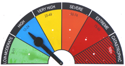
A catastrophic fire danger rating is as bad as it gets
While some homes may survive a severe or extreme fire if you’re well prepared, the Country Fire Authority says no homes are designed to withstand catastrophic conditions
If a fire starts and takes hold during catastrophic fire conditions, the weather bureau says it will be “extremely difficult to control” and take “significant firefighting resources”
This is the first time a catastrophic fire warning has been issued in Queensland
When these warnings are issued, your only safe option is to leave the area early
The catastrophic category was added following the 2009 Black Saturday fires in Victoria
Power Outages
Power Outages if updates not available here, then go here for a direct link https://www.energex.com.au/home/power-outages/emergency-outages
Tide Times at Beachmere
Sea Craft and Boat Advisories
Public Transport
Other Warnings