Short term weather trends 2018-2019 Season
Please note: Weather information is guided by the Bureau Of Meteorology , Oz Cyclone Chasers , Moreton Bay Regional Council and observations at Caboolture & surrounding districts of the Moreton Bay Region at 101.5 FM
Current Weather Events:
Very Short Term Weather/Month ahead
April 25 to May 5
Average Autumn conditions coastal showers in regular successive days during this period with sunny breaks.
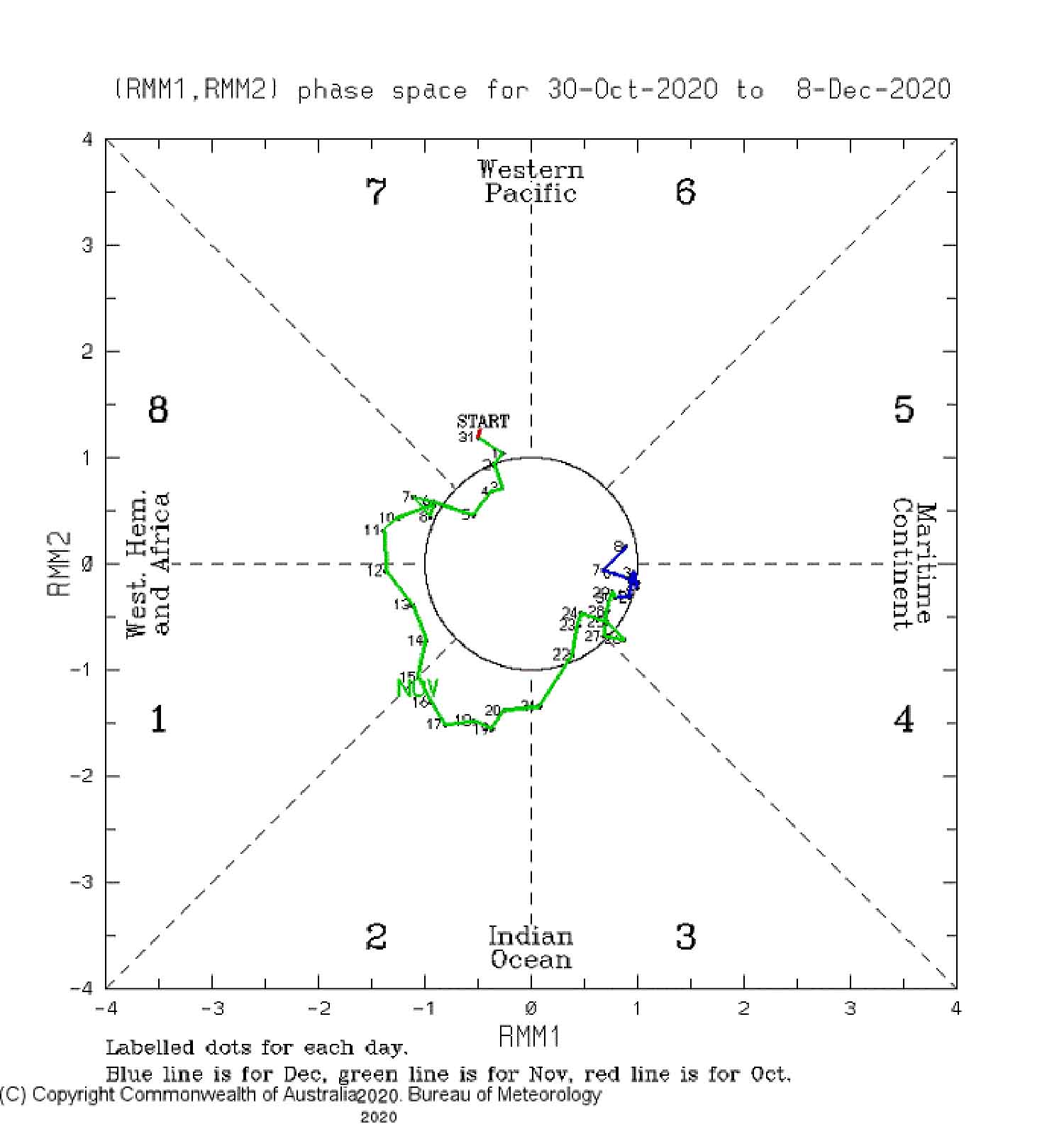
We are now in a Threshold El Niño pattern with soe cooling in effect in the Equatorial Pacific and this should continue through the winter and on to spring with indicators it may go more to El Niño / La Niña Neutral status, a warming in the indian Ocean will possibly impact with more rain during winter, this will impact on West Australia and Southern Australia and virtually no impact on Queensland. The outlook for next summer could be more neutral conditions expected with an average year of rainfall for Queensland and average cyclone activity.
Storms and Supercells:
None
Current Cyclones impacting on South East Queensland
None
Bureau Of Meteorology Cyclone Bulletin
None
Handy Links & Moreton Bay Regional Council Advisories
Important Contacts and Links
Sandbags in the Moreton Bay Region
Get Moreton Bay Regional Council : Moreton Alert
Life threatening emergencies: Triple Zero (000)
SES flood or storm assistance: 132 500
Council: (07) 3205 0555
Council local road conditions at council’s website
Unitywater: 1300 086 489
Energex: 13 62 62
Parking vehicles under solid shelter, with the handbrake on and in gear
Putting wooden or plastic outdoor furniture in backyard pools or inside with other loose items
Drawing curtains and shutting doors
Packing a kit with essential medications, baby formula, nappies, valuables, important papers, photos, mementoes in waterproof bags, as part of emergency kits
Checking neighbours — especially new arrivals — are aware of the situation and are preparing
Remaining indoors with pets, not moving to public shelters unless advised by local authorities
Keeping a battery operated radio and Staying tuned to local radio 101.5 for further information
Plus Moreton Bay region Checklist:
- Know the risks – think about the risks in your local area. How could a cyclone, severe storm, flood or bushfire impact you?
- Prepare your family – prepare an emergency plan about how to respond to local risks, including an emergency kit of essential items including a torch, battery operated radio and spare food and water (for at least three days).
- Prepare your property – check your gutters, roof, and insurance for house and other property. Get to know your neighbours and see if you can work together to get ready.
- Stay alert – tune in to warnings with MoretonAlert (register at Moreton Alert or call council 3205 0555), listen to radio updates or log onto the Bureau of Metereology’s website.
- Take action – activate your emergency plan, locate your emergency kit, secure loose items and if you are evacuating do so early and check road conditions before setting off.
For more information: https://getready.qld.gov.au/be-prepared and Moreton Bay Regional Council Disaster Portal
- Re-check your property for any loose material and tie down (or fill with water) all large, relatively light items such as boats and rubbish bins.
- Fill vehicles’ fuel tanks.
- Check your emergency kit and fill water containers.
- Ensure household members know which is the strongest part of the house and what to do in the event of a cyclone warning or an evacuation.
- Tune to your local radio/TV for further information and warnings.
- Check that neighbours are aware of the situation and are preparing.
https://getready.qld.gov.au/be-prepared
Moreton Bay Regional Council new webpage official Sandbags Locator
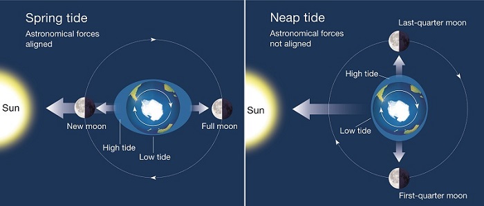
Tide Times at Beachmere
High Tides
Monday 7:27 am (2.49m), 7:53 pm (2.01m); Tuesday 8:20 am (2.59m), 8:45 pm (2.15m); Wednesday 9:09 am (2.65m), 933 pm (2.27m); Thursday 9:53 am (2.63m), 10:18 pm (2.35m); Friday 10:36 am (2.56m), 11:02 pm (2.4m); Saturday 11:17 am (2.42m), 11:45 pm (2.4m); Sunday 11:57 am (2.24m); Monday 12:28 am (2.35m), 12:37 pm (2.04m); Tuesday 1:12 am (2.27m), 1:19 pm (1.84m); Wednesday 2.16m), 2:10 pm (1.67m); Thursday 3:01 am (2.07m), 3:23 pm (1.56m) 0.86m
Sea Craft and Boat Advisories
Dams Update
For more information please visit:
Dam release information seqwater.com.au
Somerset Council somerset.qld.gov.au
MBRC Council moretonbay.qld.gov.au
Weather warnings, river heights bom.gov.au
Road closures and transport qldtraffic.qld.gov.au
Flood Watch Advisories
None
Road closures
0 road currently closed
Power Outages
Power Outages if updates not available here, then go here for a direct link https://www.energex.com.au/home/power-outages/emergency-outages
Other Warnings
If Its Flooded – Forget it !!
In the event of heavy rain falling, police are urging motorists to drive to conditions and heed the message: if it’s flooded, forget it.
Under severe storms or heavy rain bands, flash flooding can occur very quickly and without any notice – even on roads that you usually travel on without any issues.
Flash flooding can cause significant structural damage to roads, so even if you think it looks safe, you can never be sure exactly what is underneath the water.
No matter what car you drive, no matter what bike you ride, no matter what shoes you wear – if it’s flooded, forget it.
Short term weather trends 2018-2019 Season
Forward Projections:
Tropical Pacific ENSO-neutral, but some recent warming observed
El Niño typically results in below average autumn and winter rainfall for southern and eastern Australia.
Tropical Pacific sea surface temperatures have warmed slightly in the past fortnight. In the sub-surface, weak warmth extends down to 175 m depth. Recent weakening of the trade winds in the western Pacific means that further warming of the equatorial Pacific is likely in the coming weeks to months.
Five of eight climate models indicate the central Pacific is likely to reach borderline or weak El Niño levels during autumn, with four models remaining above threshold levels into winter. El Niño predictions made in late summer and early autumn tend to have lower accuracy than predictions made at other times of the year. This means that current forecasts of the ENSO state beyond May should be used with some caution.
The Indian Ocean Dipole (IOD) is neutral. The IOD typically has little influence on Australian climate from December to April.
No matter the outlook, there is still a chance of devastating cyclones this season so it pays to be prepared.
Notes
Always monitor our Facebook page and listen on air on the FM band 101.5 Mhz or listen live via our website above.


