Evening Forecast (Short)(Updated 5:11 pm)
(Updated 8:17 pm)
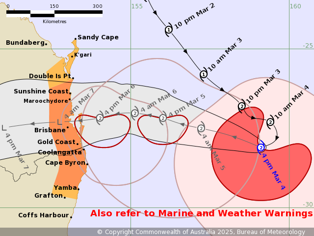
Cyclone Alfred is expected to make land fall at this stage Thursday night or Friday morning, somewhere between The Sunshine Coast and Gold Coast, however any changes to atmospheric conditions may change both trajectory and intensity. The Models are now looking towards a more southerly crossing between Brisbane and Gold Coast
We Will update these pages in real time as conditions or details change.
It is essential you play your role in planning for emergencies for your self, your family, property, pets and livestock.
Current Summary:
Up to Thursday not a great deal of change in our weather.
Tropical Cyclone Alfred is moving west towards the southeast Queensland coast.
Alfred is a category 2 cyclone and is forecast to maintain this intensity as it approaches the southeast Queensland coast on Thursday. Alfred is expected to cross the coast late Thursday or early Friday morning.
As the Cyclone travels closer to the coast then we expect Significant change on Thursday will be southerly off coast gusty at times. In the afternoon and evening expect category 1 winds of 35 to 50 km/h winds and possible category 2 winds more off shore extending from sunshine coast to Brisbane. The heaviest winds will come before the Cyclone and not with the Cyclone. The exposed areas south and south east of Bribie Island, Redcliffe, Moreton and North Stradbroke Gold coast and Hinterland and Northern NSW will feel the brunt of the gusty and sustained damaging winds. Inland brisbane, Strathpine, Caboolture, will be some what insulated by both the land itself and from Moreton and North Stradbroke protecting us from full force of those winds.
Expected landfall sometime Thursday night and Friday Morning, somewhere between Sunshine Coast and Gold Coast and more likely between Brisbane and Gold Coast.
Winds will moderate Friday, the cyclone will die inland but rain will be influenced by post cyclone moisture channels from the Coral sea feeding in moisture for some sustained rain for a few days in South East Queensland.
Rain will be in extreme levels for Gold Coast, northern NSW, inland Scenic Rim and up to Toowoomba areas like Brisbane and North of Brisbane or sunshine coast will get little rain based on current models..
Essential Weather links so you stay in the know: (all links will open in a new tab)
City of Moreton Bay Disaster Dashboard
BOM Hazardous Surf Conditions for South East Queensland
BOM Marine Wind Warning Summary for Queensland
BOM Flood Watch for South East Queensland
Stay Safe and connected Non Weather Related useful Links(all links will open in a new tab)
Queensland Police – Ring 000 (Triple Zero)
Policelink – Non urgent matters – Ring 131 444
Queensland Ambulance – Ring 000 (Triple Zero)
Queensland Fire – Ring 000 (Triple Zero)
General Advise to the public.
Impacts
- Very strong winds may knock down trees, powerlines, blow roofs off some houses, and blow away anything not tied down outside. This is a risk to life.
- Power, phones, internet and water might stop working. They could be out for a long time.
- Heavy rain and storm surge may cause flooding in some places.
- Roads could be blocked by fallen trees, powerlines or flood water.
- Some places could become isolated.
What Should You Do?
- Consider your risk of isolation and/or flooding.
- Think about where you would evacuate to, this could be with family or friends in a safer location.
- IF IT’S FLOODED FORGET IT! Your car can’t protect you from floodwater.
Prepare your home
- Store or tie down outside items like caravans, trailers, outdoor furniture, gas bottles, toys and play equipment.
- Move outdoor furniture inside or if you have a pool, sink plastic outdoor furniture in the pool so it doesn’t fly around in strong winds.
- Check for tree branches hanging over your roof. Cut them off if you can.
- Make an emergency plan and kit.
- For further information go to Get Ready Queensland website
Tourists and visitors, campers and caravanners
- Campers and caravanners should think about packing up now.
- Visitors who do not need to stay in the area should plan to leave.
- Leaving now is a safe option. Airports and highways could close if the cyclone gets closer.
- If you choose to stay, ask accommodation staff where to shelter if the cyclone hits.
If you have a boat or jet-ski
- Prepare early. Remove your boat, jet-ski, canoes or kayaks from the water and store securely on land if possible.
- If your boat is kept on the water, check your moorings and get ready now to relocate it to a safe mooring.
- If your boat is in a marina, check-in with the marina manager.
- Check your area’s Extreme Weather Contingency Plan on the Maritime Safety Queensland website.
If you have livestock
- Consider moving livestock to higher ground. You may need to open gates to other paddocks so animals can move to safety.
- Block access to low-lying fields or other places near creeks and rivers.
- Provide lots of food and clean water in a safe place away from creeks and rivers.
- Make sure animals can be identified if they get lost. This may include brands or tags.
- Prepare for isolation
More Information
- Traffic information and closed roads, go to the QLD Traffic website or call 13 19 40.
- Public transport information, go to the Translink website.
- Listen to your local radio station: ABC Brisbane 612AM, 99.7FM, 101.5FM.
- For emergency help in floods and storms, call the State Emergency Service on 132 500.
Cyclone Alfred Issued at 4:43 pm AEST Tuesday 4 March 2025. Refer to Tropical Cyclone Advice Number 6.